-40%
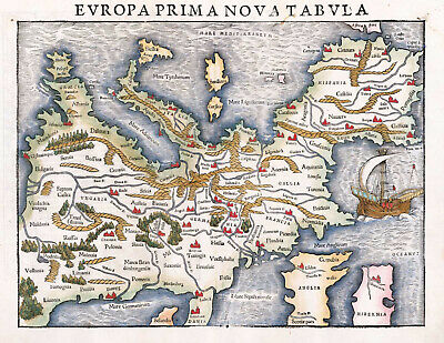
1542 Pictorial Map of Europe Sebastian Münster 11"x14" Art Print Decor Artwork
$ 6.6
- Description
- Size Guide
Description
The First Printed Map of EuropeDetailed Specifications
This is a Reproduction of the Original Map.
Print Size: 11"x14"
This size is more for decor than to study.
This Print Comes in other Sizes too:
16"x21" and 23"x30"
You can find it and more
Map of Europe
in
Our Store
We have more
Pictorial Maps
in
Our Store
All Our Posters and Maps Are
Made in the USA
REMEMBER,
the smaller the map size the harder it is to read the text.
Munster's first modern map of Europe, with south oriented at the top of the map and a large sailing ship in the Atlantic.
Munster's Geographia was a cartographic landmark, including not only Ptolemaic maps, but also a number of landmark modern maps, including the first separate maps of the 4 continents, the first map of England and the earliest obtainable map of Scandinavia. Munster dominated cartographic publication during the mid-16th Century. Munster is generally regarded as one of the most important map makers of the 16th Century.
This map comes with a white border around the image
---------------------------
-How are the prints shipped?
They are rolled and placed into a rigid tube or box.
-Is this available in a larger/smaller size.
Yes. For smaller or larger sizes, email us.
