-40%
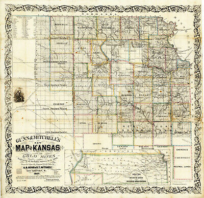
1862 Map of Kansas Gold Mines 11"x12" Wall Art Print Mining Map Gold Rush Decor
$ 6.6
- Description
- Size Guide
Description
Kansas And The Gold Mines.Showing routes to the Mines
Detailed Specifications
This is a reproduction of the original map
Print Size: 11"x12"
This Print Comes in other Sizes too:
16"x17" and 23"x24"
You can find them and more
Gold Region and Mining Maps
in
Our Store
We have more
Maps of Kansas
in
Our Store
All Our Posters and Maps Are Made in the USA
Remember,
the smaller the map size, the smaller the print, that means it is harder to read the text!
The two smallest sizes are more for decor than to study.
The map is of eastern Kansas west to the 98th meridian, with an inset of the "Routes from the Missouri River to the Kansas Gold Mines." This inset does not show Colorado, even though it was formed in 1860. There is a list of the Population of Kansas Counties, and a vignette of an Indian.
This map comes with a white border around the image
---------------------------
-How are the prints shipped?
They are rolled and placed into a rigid tube or box.
-Is this available in a larger/smaller size.
Yes. For smaller or larger sizes, email us.
