-40%
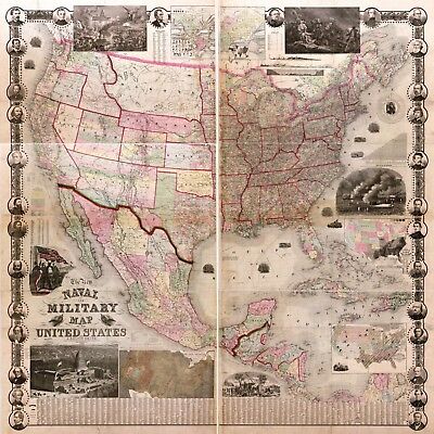
1862 Naval Military US Civil War Map 11"x11" History Antique Wall Decor Poster
$ 6.6
- Description
- Size Guide
Description
1862 Map: The new naval and military map of the United StatesDetailed Specifications
This is a reproduction of the original map
Print Size: 11"x11"
This Print Comes in other Sizes too:
16"x16" and 23"x23"
Remember,
the smaller size map, the harder to read the text.
The 2 smallest sizes are more for
décor
than to study.
We have more
War
Maps
, you can find them in
Our Store
We have more
War
Posters
, you can find them in
Our Store
All Our Posters and Maps Are Made in the USA
Map of the United States, Mexico, and Central America showing national, state,
and county boundaries, cities and towns, mail routes and wagon roads, railroads
built and in progress, canals, and relief by hachures.
Map showing the fall of rain and mean annual temperature with the mountains,
plains & river systems of the United States.
Map showing the distribution of the slave and free colored population of the
United States.
Map showing the distribution of staples in colors with the principle articles of
export marked in the states severally also the distribution of plants, trees, and
animals.
This map comes with a white border around the image
---------------------------
-How are the prints shipped?
They are rolled and placed into a rigid tube or box.
-Is this available in a larger/smaller size.
Yes. For smaller or larger sizes, email us.
