-40%
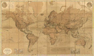
1863 World Map Mercators Projection Vintage Antique Look Wall Art Poster 9.5x16
$ 6.6
- Description
- Size Guide
Description
1863 Chart Of The World On Mercators ProjectionDetailed Specifications
This is a reproduction of the original map
Print Size: 9.5"x16"
This Print Comes in other Sizes too:
16"x26.5" and 23"x38"
You can find them and more
World Maps
in
Our Store
All Our Posters and Maps Are Made in the USA
Elaborate map showing shipping routes, etc.
The confederate states are shown as subtly separate from the rest of the U.S. and
a large Montana territory occupies Idaho and Montana, with Idaho in Wyoming!
Ocean currents are shown, relief is conveyed in great detail, and thematic inset
maps abound.
This map comes with a white border around the image
---------------------------
-How are the prints shipped?
They are rolled and placed into a rigid tube.
-Is this available in a larger/smaller size.
Yes. For smaller or larger sizes, email us.
