-40%
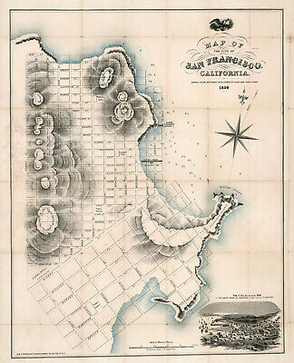
Earliest Map of San Francisco 1850 History 11"x14" Wall Art Poster Print Artwork
$ 6.6
- Description
- Size Guide
Description
Map of The City Of San Francisco, California 1850.One of the earliest maps of San Francisco..
Detailed Specifications
This is a modern reproduction of the original map.
Map Size: 11"x14"
This map comes in other Sizes too:
16"x20" and 23"x28"
You can find them and more
Maps of San Francisco
in
Our Store
Remember,
the smaller the map size, the smaller the print, that means it is harder to read the text!
All Our Posters and Maps Are Made in the USA
The Large Vessel At The Wharf is The "Apollo Store Ship."
Shows all streets, Agnew's Steamboat Landing, Central Wharf, and the Apollo Store Ship.
Scale given in Mexican Varas.
With an inset view of the city in 1849.
Elevations of the hills and coastal cliffs are show with hachures.
Harry J. Peters says of the Apollo Store Ship: It "was sent around the Horn from New York in 1849 to San Francisco. There it was beached & converted to a store & warehouse. This was often the fate of many ships in those days when whole crews would often desert ship & rush to the gold fields. It was also profitable to the owners to beach a vessel & turn it to just such uses as the Apollo, for San Francisco was largely a city of tents with few buildings either for homes or storage for the thousands of newcomers."
This map comes with a white border around the image
---------------------------
-How are the prints shipped?
They are rolled and placed into a rigid tube.
-Is this available in a larger/smaller size.
Yes. For smaller or larger sizes, email us.
