-40%
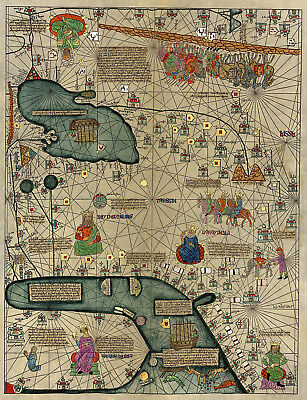
Mapamundi Cresques Catalan Atlas World Wall Map 1375 Mapamondi 3rd leaf 11"x14"
$ 6.6
- Description
- Size Guide
Description
Abraham Cresques 1375 Catalan Atlas 3rd LeafDetailed Specifications
This is a modern reproduction of the original map.
Map Size: 11"x14"
This Map Comes in other Sizes too:
16"x20" and 23"x30"
We have them and the other 3 leaves
Our Store
We have more
World maps
in
Our Store
All Our Posters and Maps Are Made in the USA
The most important map of the medieval period - the so-called Catalan Atlas, drawn by the Majorcan cartographer Abraham Cresques in 1375.
Consists of 4 leaves - the first two covering most of Europe, the 3rd one Middle East, and the last one China.
Includes beautiful illustrations of kings, animals, and a caravan on the Silk Road, described by some historians as the caravan of Marco Polo (4th image).
In 1375, Cresques and his son Jehuda received an assignment from Prince John of
Aragon (the future John I of Aragon) to make a set of nautical charts which would go beyond the normal geographic range of contemporary portolan charts to cover the East and the West, and everything that, from the Strait [of Gibraltar] leads to the West.
For this job, Cresques and Jehuda would be paid 150 Aragonese golden florins, and 60 Mallorcan pounds, respectively, as it is stated in 14th-century documents
from the Prince himself and his father Peter IV of Aragon. Prince John intended to present the chart to his cousin Charles (later to be Charles VI, King of France) as a gift.
In that year 1375 Cresques and Jehuda drew the six charts that composed the Catalan Atlas at their house in the Jewish quarter of Palma./wiki
This map comes with a white border around the image
---------------------------
-How are the prints shipped?
They are rolled and placed into a rigid tube.
-Is this available in a larger/smaller size.
Yes. For smaller or larger sizes, email us.
